GPS for RTLS: outdoor yards and campus handoff
GPS and the wider GNSS family belong outdoors: yards, lots, and campus roads with sky view. This page covers what ordinary modules really deliver, when you need specialized hardware, and how outdoor track hands off to an indoor RTLS.
What GPS is
GPS is a satellite navigation system. A receiver on a trailer, yard tractor, container, or person hears several satellites, measures travel time, and computes a geographic position. GNSS is the umbrella name that includes GPS plus other constellations. Plant trackers usually run multi-GNSS chips. The result is a lat/long (or a plant-map transform of that), not an indoor radio fix from hall anchors or a Wi-Fi fingerprint.
GPS sits beside other RTLS options as a peer. It fits outdoor storage, parking lots, gravel yards, and campus lanes where the sky is visible. Brochure and phone-app numbers often quote about 3–5 m (10–16 ft) outdoors under open sky. Real user accuracy still depends on antenna, satellite geometry, blockage, and receiver quality. On plant yards with moving assets and ordinary tracker modules, twinzo deployments commonly see the reported location jump about 20–50 m (65–165 ft). A standing-still receiver with a clear sky may settle closer to the brochure band. Once the asset moves beside steel edges with a stock antenna, that settle rarely holds. Tighter outdoor accuracy needs differential or RTK-class corrections plus proper antennas, not a bare consumer module. Indoors under steel and concrete, satellite signals drop or lie. Match the job to the technology first. The decision order sits under start with the decision, not the technology. The wider menu is in RTLS technologies out there.
How GPS gets a location
1. Satellites broadcast time and orbit data - The receiver needs a clear view of enough satellites. Buildings, dense canopy, stacked containers, and urban canyons cut that view and stretch the error.
2. The tracker computes position on the device - Multi-GNSS modules output coordinates, and often speed and heading. On a moving yard asset with a basic module and stock antenna, expect the location to wander about 20–50 m (65–165 ft). Optional RTK or differential corrections, plus proper antennas and specialized hardware, are what tighten the outdoor fix. Standing still helps a bare module settle. Motion does not.
3. A network path moves the result - The small position packet leaves the asset over LoRaWAN, LTE (4G / 5G), Wi-Fi, or another IP path into WMS, a yard management system, or the twin. That path does not create the satellite location.
4. Indoor handoff at the door - At the threshold the plant usually switches to an indoor modality. Peers for that indoor stream include BLE, UWB, RFID, VHF, and SLAM. One twin map should show both layers so search does not stop at the roof line. The handoff rule itself is under outdoor yard GPS vs indoor hall track.
Strengths
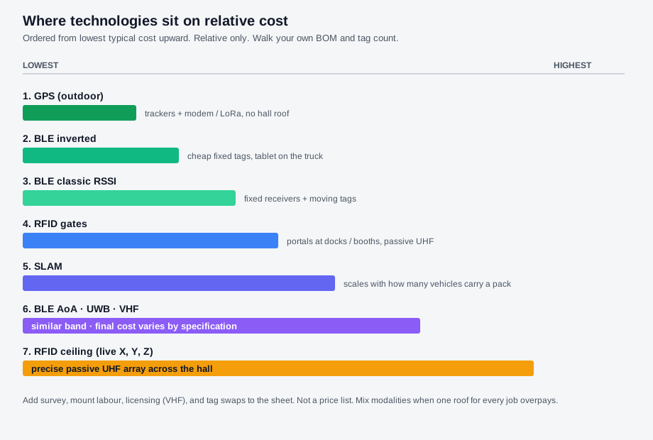
No ceiling anchors for outdoor jobs - Yards and lots do not need hall ceiling anchors for coarse outdoor presence. The sky is the infrastructure when line of sight to satellites holds.
Coarse outdoor presence at campus scale - With ordinary modules, GPS is honest for which lot or which large part of the yard, not for an exact parking-slot mark. Gate and apron geofences still work when the jump budget is tens of metres (about 65–165 ft). That is outdoor zone presence, not medium-precision aisle work.
Campus continuity with cellular or LoRa backhaul - Sparse outdoor assets can report for hours or days on battery when update rates stay honest. The network path is separate from how tight the satellite fix actually is. That feed still lands on the twin used for internal logistics and outdoor asset tracking once coordinates are mapped to the site model.
Weaknesses
Under roofs, mezzanines, and heavy steel, satellite signals drop or report false positions. Do not buy GPS for indoor aisle search. RTK and differential builds can tighten outdoor fixes, but they add reference infrastructure, antennas, correction service, and cost. Battery life still trades with update rate. Stacked containers and building edges create multipath that can report a valid-looking fix on the wrong row. Put modem plans, antenna choice, correction service, mount labour, and handoff design on the payback sheet in what to include when calculating RTLS ROI.
When GPS fits
1. Name the outdoor question - Which trailer is in which lot or large yard zone, which tractor is approaching the gate. If the answer can be wrong by about 20–50 m (65–165 ft) on a moving asset with ordinary GPS hardware, the stack is in range. If you need a few metres (about 10–16 ft) while things move, budget specialized antennas and correction hardware before you buy the equipment.
2. Design the door handoff - Decide which indoor technology takes over inside, and put both streams on one map. GPS alone stops when the asset goes indoors under the roof. Keep yard object classes and hall object classes on separate success tests, as framed in tagging the mover vs tagging the material.
3. Separate location from network path, then land one map - Satellites create the location. LoRaWAN, LTE, or Wi-Fi moves it. Then show the stream on one digital twin next to indoor movers for logistics and production monitoring. Peer technology pages sit under RTLS technologies out there. Definitions start at what is RTLS. Product capabilities are on the features overview.
Pick GPS when the job is outdoor and sky-visible, and plan the indoor layer as a peer rather than a hope. Get in touch if you want to walk that handoff on your own facility model.