Spatial data has to exist before the model does anything useful
Manufacturing AI talks often jump straight to the model. Without positions in space and time for movers and material, that model has nothing honest to learn from.
What the model actually needs to see
Rows in a table are not enough. A forklift's location a few seconds ago, the dwell of a pallet at a gate, and the path a material handler took during the last shift are the kind of facts that let later analysis join logistics, production state, and environmental conditions. Without that spatial layer, correlation stays guesswork. Industry maturity models for digital twins usually put monitoring and live sync before predictive capability for the same reason.
Building the layer is the unglamorous part. It means real-time location system (RTLS) coverage dense enough to produce usable coordinates, feeds that arrive with consistent timestamps and clear ownership, and enough history stored so past shifts can be replayed. None of this is the AI model. It is the prerequisite spend that has to land in the plant first. How prediction waits on that stored history is under predictive digital twins wait on stored history.
Tag and anchor density is the first hard cost
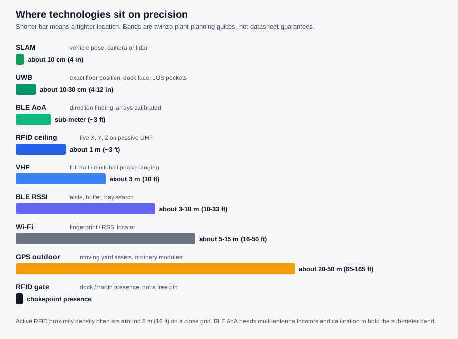
Accuracy is technology-dependent. BLE typically delivers medium precision around 1–3 m (3–10 ft), which is enough for most aisle, buffer, and bay logistics work. UWB can reach sub-meter (~3 ft) when the job needs exact floor position. Coarse zone presence answers which wing or chokepoint. Those bands are different jobs. Do not treat medium precision as coarse zone presence, and do not treat every no-go as a sub-meter requirement.
In a 30,000 m² (about 323,000 ft²) plant, that difference decides whether a bay boundary is trustworthy or just noise. Enough fixed anchors have to be placed so tags report without dead zones, and every asset or person that matters needs a tag. Battery life often runs one to three years on many BLE tags. UWB units often need more frequent charging. Installation is not a software exercise. Fixed sensors or readers go in, assets get tagged, the system is calibrated. Typical full deployment runs one to three months. The hardware, mounting labor, and network load are real plant costs that appear long before any model training budget is opened.
Governed feeds turn raw locations into a usable dataset
Locations alone are not enough. The platform has to ingest them alongside data from MES, ERP, WMS, or SCADA so each location point can be joined to order status, equipment state, or material identity. twinzo functions as the umbrella layer for that ingestion inside an operational digital twin. The feeds themselves still need governance: consistent timestamps, role-controlled access, clear rules on what is tracked and why.
Without that discipline the spatial set fragments. One system updates every few seconds, another only on events, a third carries no location context at all. The joins fail and any later model inherits the mess. The cost here is less about license fees and more about the engineering time spent defining ownership, cleaning the streams, and keeping them aligned after the first pilot ends. Why organized streams still lacked place is covered in organizing the streams came first.
Replay infrastructure is the quiet enabler
Once the live layer is running, history becomes the next requirement. The ability to replay locations months or a year back, generate spaghetti diagrams, heat maps, and zone-activity reports turns a live map into a training and audit resource. Engineers can return to a shift that went wrong, examine the actual routes taken, and test whether a proposed change would have altered the outcome. That stored place-and-time record is the spatially oriented dataset, the plant form of spatiotemporal data.
Storage, retention policy, and the compute to serve those replays are again separate from model cost. They sit in the same category as the anchors and the governed feeds: necessary infrastructure. Without them the spatial dataset stays ephemeral. Models can only learn from what is still retained and still linked to the original locations. Historical replay is therefore not a nice-to-have demo. It is how the plant proves the record is dense enough to ask later questions.
Three equal jobs the spend has to fund
None of this spend exists only to feed a future AI pitch. Live internal logistics reaction uses the map on this shift for search, fleet load, and waits. The spatially oriented dataset under that view is the reality replica continuous improvement and later models need. Correlation and causality analytics use the same history when place-and-time pairings keep preceding stops. Those three jobs stay equal. A plant that funds only hunt-and-find, then expects AI to invent causality from thin tables, has not finished the prerequisite.
Funding the map, the stored record, and the analytics in that order is a practical smart manufacturing and lean manufacturing path. Why location-aware data changes the AI conversation once the record exists is under why location-aware data changes the AI conversation. twinzo ships the operational layer that collects those locations and states today, supporting internal logistics optimization and production monitoring while the dataset underneath accumulates. Capability detail lives on the features overview.
The spend stays unglamorous for a reason
None of this appears on the glossy AI slide. It shows up as tag purchases, anchor mounting, network upgrades, data-governance workshops, and a year of location history sitting on disk. The plant still has to decide whether the density is high enough, the feeds clean enough, and the retention long enough before any model is asked to find patterns. That decision is the real starting point for AI that claims to understand manufacturing space and time.
Get in touch if you want to size the spatial prerequisite against one question your hall can already name.