The map has to match what they already know
AI work on a plant floor only becomes useful after the people who walk the hall trust the spatial picture. Supervisors confirm whether locations, routes, and dwell match what they already know.
Who confirms that the picture is true
Supervisors and shift leads notice first if a forklift location sits in the wrong bay or a material movement never happened the way the screen claims. Data engineers can confirm APIs and timestamps. Only the people on the floor can confirm whether the picture matches the hall. Both checks matter. Only one of them decides whether the map becomes a shared reference or decoration.
twinzo builds that picture as a live operational digital twin. It ingests real-time locations from a real-time location system (RTLS) for forklifts, people, and materials, and overlays other plant data inside a 3D model. The result is a spatially oriented dataset: where something occurred, when, and how it related to everything else nearby. That spatial layer is what supervisors eventually use, not a spreadsheet of coordinates. How the operational type is defined is covered in operational digital twins show the shift.
What they check against direct observation
Trust starts with simple verification. Can they open the live 3D view and see the same forklift they just watched leave the staging area? Does a spaghetti diagram of yesterday's routes match the paths they know drivers actually take? Can they replay a shift and watch a known delay appear exactly where it happened?
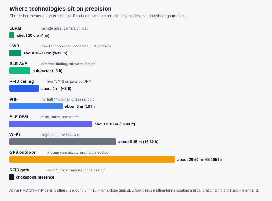
Accuracy is technology-dependent. UWB can offer sub-meter (~3 ft) accuracy when the job needs exact floor position. BLE typically provides medium precision around 1–3 m (3–10 ft) for aisle, buffer, and bay work. Supervisors do not need the marketing claim. They need to walk the floor with a tablet and confirm the locations land close enough for their decisions. Historical replay, heat maps, and customizable reports let them test longer patterns the same way.
People tracking adds another filter. Location data is encrypted and access is role-controlled. Personal tracking is always opt-in and justified by a concrete use case such as safety. Supervisors will ask who can see what and under which rules. Clear answers remove one more reason to doubt the system. Data governance here is not a side policy. It is part of whether the floor will use the view.
People path beside the technical path
The technical path usually starts with a business question, trustworthy data, a pilot, measurement, then scale. That sequence is covered in clarify the business question first. The people path runs in parallel and often decides whether the technical path survives. Supervisors and shift leads are the daily users of the spatial view. If they treat the 3D map as decoration or ignore the notifications, later AI layers have nothing reliable to work with.
A typical pilot runs in two to four weeks. That window is long enough for supervisors to test the live map against real shifts, and short enough that they still remember the exact events they are checking. During those weeks the question is not whether the model looks advanced. The question is whether the locations, routes, and dwell times line up with what the floor already knows. What the pilot costs to learn, and what pass criteria apply, are covered in what a two-to-four-week hall pilot actually costs to learn.
Signals that stick
Three signals tend to settle the matter. First, the live view updates often enough that a moving asset does not jump or lag in ways that contradict direct observation. Second, replay and historical reports let a supervisor pull a specific incident and show colleagues the same sequence. Third, role-based access and opt-in rules for people data make the privacy conversation concrete instead of theoretical.
Once those signals hold, the spatial dataset stops being a project deliverable and becomes a shared reference. Supervisors start using it to brief the next shift or to resolve a logistics dispute without walking the entire floor. Only then does the conversation about AI analysis of that same dataset become practical rather than speculative.
Three equal jobs sit on that trusted record. Live internal logistics work uses the map today. The spatially oriented dataset under the view is what continuous improvement and later models read. Correlation and causality analytics use the same history for hall-wide pattern work. Those three stay equal. A map that only earns trust for hunt-and-find, then never stores the shift, has not finished the job the twin is supposed to do. Keeping those three jobs equal is a practical smart manufacturing move.
Trust first, then models
The technical sequence still matters, but it does not replace the trust check. The people sequencing is simpler and stricter. The floor has to trust the spatial picture first. Without that, the rest stays on the whiteboard. twinzo's present job is the live facility view and the dataset underneath it, feeding internal logistics optimization and production monitoring once people believe what they see. Capability detail lives on the features overview.
Get in touch if you want to walk the same trust checks on your own facility model.